NEDO Develops a Surveying System Allowing for Cooperation between GPS Markers and Drones with Commercialization Coming Soon
Date: June 30. 2017
Source: NEDO
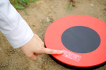
Utilizing the results of a NEDO project, Aerosense Inc. has developed a GPS built-in ground control point “AEROBO® Marker” with the aim of reducing survey man-hours and post processing time at construction sites. By installing these markers at construction sites, survey markers can be easily placed, eliminating time and effort otherwise consumed by additional survey man-hours.
Continue reading »